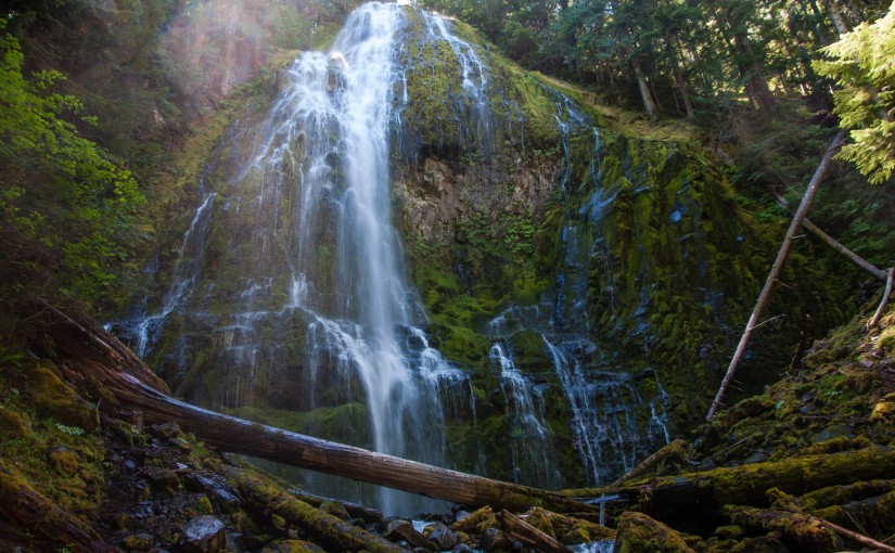
Proxy Falls: Three Sisters Wilderness

Lao Tzu is credited with saying that “the journey of a thousand miles begins with a single step”.  In this day and age, we might change that last word to “click”.  Most of us make our arrangements for journeys, or get ideas on where to go and what to do over the internet.

_DSC1467Proxy Falls was such a case for us.  I had seen a picture while browsing earthporn images (arousal images for nature lovers, ha) and downloaded it as my wallpaper for my computer at work.  I decided to look up where that place was in the picture, and learned that this falls was located in the Three Sisters Wilderness outside of Bend, Oregon.

20150619_101920I stashed the information away on where it was located in case we ever made it to that area.  Well, in June, I was headed there for my work conference, and it looked like I would have enough spare time in the schedule to make the 1.5 hour drive out to the location, hike the (what we thought to be) four mile round trip, and make the drive back.

We_DSC1422 weren’t sure how hiking with baby Sebastian would work, but Jason always felt confident that he would be able to use the baby backpack to carry him, and that it would not slow us down terribly.  Of course, then he told me he would need to get in shape to be able to carry him four miles, and then never actually started working on that plan.  So I was a little apprehensive about our ability to complete the hike, given the extra weight, but it turned out to be little problem.

It was a good idea that we agreed that Jason would carry him, because despite the fact that the it was supposed to be an “easy hike, perfect for families”, it required a little agility to cover the initially-rocky trail, made doubly difficult by my still-wonky right ankle.  I am not sure why I thought the distance was that far, unless that distance was if you traveled clockwise along the loop, but going counter-clockwise provided a 20150619_103052fairly short walk for us to the base of the falls.  In looking up information afterwards, it appears it is only 1.5 miles, so perhaps I was just working off false information.  Luckily for us this time, the error was in our favor.

The trail was a mix between the rocky remains of a lava field and the ferny, mossy shadowy depth of the type of forest that I absolutely love.  There were flowers blooming along the trails, like these little purple bells cast about in shady little corners (or occasional patches of sunlight, like this):

_DSC1494

There were patches of rhododendrons, and some other flute-like orange flowers that I don’t know the names of.  I really need to get on with the plant-learning business over here.  I was in heaven with the moss and the ferns.

We had some debate on whether or not I should have bought the parking permit, because where we stopped to buy it, the lady (who admitted she was new to this) said they only had one kind of pass, which was a one year NW (Washington-Oregon) Pass for $30.  Although Jason thinks I should have just not bought the darn thing then (we were thinking $5-$10 range for day pass), in the end I felt more secure having it since the rangers had stopped at the parking area as we were leaving to clean the facilities (and presumably check for parking permits).  So, if any of you are in the need for a parking permit for national recreation land in that area over the next year, let me know – have I got a deal for you – one lightly used pass, bone of contention.

Here are some other pictures from along the trail:

20150619_102530 _DSC1512_DSC1507 _DSC1501 _DSC1495 _DSC1473


These pictures below of the actual falls are some of my favorite pics from our journey. One we reached the base of the falls, we had to sort of scramble around to actually get up to the falls, which on one hand made me nervous that Jason was doing, and on the other, I couldn’t resist doing myself.

_DSC1463 _DSC1444 _DSC1456 It was simply awesome to actually get there in person, to feel the gentle spray on your face coming off the falls, and hear the rushing stream of water in person. All said, it was the best hike of our year so far, and probably the highlight of the year altogether.  These are the moments we aren’t likely to forget.

Big Thicket National Preserve

20150523-_DSC1319Last Saturday found us in the visitor center for the Big Thicket National Forest, north of the town of Kountze.  We had stopped in briefly to get information on trails, and now we were back for a respite from the muggy humidity and the bugs after an hour long hike on the Kirby Nature Trail.  I sat in the darkened theater room to feed the baby, and the friendly park ranger who was working the front desk offered to start the movie for me.  We watched the fifteen minute film that offered some insight on what makes this preserve special.

One of the features of the park that make it unique is its diversity.  The Big Thicket is actually a collection of several tracts of land spread out over several counties and 84,500 acres.  It happens to sit right at the junction of several different ecosystems.  A hiker might be able to cross through nine different ecosystems throughout a visit in the park, from the pineywoods of east Texas to the hardwoods of the Mississippi, from savannah to desert.  Due to this intersection, visitors will be able to find a wider variety of species than in any other area of Texas: over three hundred species of migrating birds, a thousand flowering plants and shrubs (including four carnivorous species), one hundred species of trees, and many species of reptiles and amphibians, including all four venomous snakes of Texas, and this cute little skink here.
skink

Buck Moth Caterpillar.  Apparently their little barbs are poisonous and leave a vicious little sting if touched.  20150523-_DSC1331

Fungus and flowers along the Pitcher Plant Trail20150523_153955

20150523_153837


This is the Pitcher Plant – one of the four carnivorous plants.  It digests insects that fall into the liquid inside this tube, which contains enzymes that break them down.  These plants are easily viewed in the springtime from a short quarter mile walk along an easy walking path (that can be a little tricky to get to, at least the way we drove to it).

20150523_153154

Given that this area of the world has been designated as the “biological crossroads of North America”, one should not be surprised that of all the strange insects, reptiles and flora and fauna of this preserve, there has been reports also of elusive hairy beasts – wood apes, aka “bigfoot” or “sasquatch”.  There have been at least fifteen reports of sightings in the counties composing the Big Thicket on the North American Wood Ape website, accounts so numerous that Bigfoot researchers have been known to take up residence in the area to keep watch. (This information was not relayed in the film we watched in the visitors center). The area was also home to most species of American mega-fauna before their extinction.

20150523_132526Stories of the people of the area that were included in the official film included that of the “Dog People”, a group of pioneer-types that lived completely off the land in this area in the mid-1900s, using their pack of dogs to assist them in hunting game in the forest to survive off of.  Also, groups of Native Americans, such as the Alabama-Coushatta, have called these woods home at some point.  The Dog People and other residents were slowly kind of forced of the forest, as it started to be exploited for its oil and gas reserves, as well as its lumber.  Eventually, though, there was enough push to get the land declared as one of the nation’s first National Preserves in 1974.  Due to its status as a preserve and not a national park, there is limited allowance for these resources to be utilized, but while retaining the area’s natural resources for the future.

20150523_131501 Another story that I came across later, not included in the film, was that of the Texas “Jayhawks”, a group of local men drafted to fight in the Civil War for the side of the Confederacy, who opposed that side’s viewpoint and hid out in the forest to avoid the war.  They were arrested at one point and held in nearby Woodville, but escaped in a scheme involving whiskey, fiddling, a loose board, and the dancing of a jig by one of the Jayhawks, which allowed the guards to be distracted long enough for all the prisoners to escape through the loose board one by one.  In the chaos that ensued after, the one who had been dancing the jig just walked away, free at last.  Later, a Confederate Captain named Kaiser decided to light a fire to the Jayhawk camp at Honey Island, trying to flush out the traitors.  It is believed that all the Jayhawks escaped, but the canebrake they lived in was permanently destroyed, and 3000 acres of forest burned up in what is now referred to as the “Kaiser Burnout”.  This is one of the ghost stories that is attributed to the mysterious “Light of Saratoga”, a ghostly light that appears and disappears at random times on Bragg Road in the town of Saratoga, sixteen miles west of Kountze.   Other explanations include ghost conquistadors looking for buried treasure, a decapitated railroad worker from a nearby accident, or an eternally lost hunter looking for a way out.  Or, perhaps, swamp gas or light reflection from cars on the nearby highway.

We had decided to take the scenic route from the visitors center to the Pitcher Plant Trail, and then may or may not have lost our way.  As we worked our way through a series of back roads, the roads eventually turned to dirt.  Occasional small houses were found along this road, or sometimes just signs with a person’s name marked on it indicating a lot or way to another property.  However, most of our drive we spent in complete wilderness, with no signs of human presence.  The preserve was on our left, and private property to our right.  I felt the presence of other life out there, though, and was half-expecting to see one of the “Dog People” in the silent woods around us, perhaps sight some unusual movement in the forest.  I didn’t see anything, though, besides a few birds not already on our list for the year.

It was a place that was enlightening and intriguing, though, and we did decide it was worth coming back to another time – just not often, as it is some two hours and change drive from our house.  There is much to explore out here.

loop_bigthicket

Camels Prairie Stash

IMG_20140717_200431Still Thursday, July 17.

As we left the logging roads that led us to Eggcellent, we headed north for another set of logging roads some 240 miles away in the panhandle.  We took Elk River Road to Highway 3, a rural highway that cut north through more typical Idaho scenery: stubby brown hillsides, hay fields, farms, and roads that disappeared around the bends only to pick back up again.

We had a music crisis that had reached critical mass around this time, two weeks into the road. I had this idea that we were all going to take turns with our music. It turned out that Jason completely forgot about this idea…forgot about music completely actually, and didn’t have a single audio file loaded on his phone except two odd voice mails that we actually did listen to in our desperateness. I never thought I would see the day, but after twenty two years as a fan, I finally burned myself out on the Indigo Girls during this trip. I couldn’t handle my own music anymore, I was so over it, despite the bonus albums I had borrowed from the library to burn copies of (apparently all “hippy dippy shit”, according to Jason). We were listening to some of that this day – some odd Peter, Paul and Mary tracks that I had never really heard – but finally we had to kill that off and go for the one thing that kept us from driving each other crazy three weeks on the road – the audio book of the first Game of Thrones story, “A Song of Ice and Fire”. At thirty three hours long, it was the perfect road companion.  We listened to this for a couple hours at a time almost every day of our trip this summer, and finally finished it off on the last stretch of road from Dallas to Houston.

We were starting to get hungry, but we didn’t drive through any real towns for quite a while on this stretch. Finally, around two pm, we reached Saint Maries, a little town that was apparently the site of a “Wobblies War” between unions and state/federal forces.  Across the street from the historical marker describing this (also a virtual cache), we found respite in Bud’s Drive In, a greasy spoon offering great burgers and cool drinks.  We had the friendliest waitress ever, who insisted on making us “Arnold Palmers” when we couldn’t decide if we wanted lemonade or iced tea, and insisted on making us to-go cups of it as we were leaving (even if I wasn’t quite convinced I liked it – it was really hard to say no to her enthusiastic spirit).

Speaking of spirit, pretty soon we were passing through Coeur D’Alene, then out into the watery and less inhabited regions of Idaho.  This sign made me want to stop and stay a while at this place,  but we were on a mission.  Maybe next time.
IMG_20140717_210459We were heading north to Priest Lake State park, a campground just thirty miles from the Canadian border.  The reason we were headed there was because this time, this year, I was going to find this particular “grandfather” cache:  Camels Prairie Stash, which is hidden off the logging roads basically across the road from the park.

This is the oldest cache in Idaho, having a hide date of 6/17/2000.  It has been found a little bit more often than the other ones we found on this day (about 150 times by the time we found it), despite the challenges in getting to it, and is owned by Moun10Bike, who is a Charter Member and legend in the geocaching world.

Mostly, I was in it for the view.  I wanted to experience this exact moment that is in this picture from the cache page (not my pic).  I love this picture:

camels prairie

This picture just seems to sum up what it is I am after in our adventures into the wild.

As I learned, it was not the right time of year for this photo…nor am I sure I want to actually be here when there is snow still on the ground.  The way to this area was rough, and I felt a little more vulnerable out here than I anticipated (might have had something to do with the fresh bear scat we saw, and that others reported seeing in their logs).   So we didn’t get THAT picture, but we did get this one, which I was happy with:GC25

I wasn’t sure we were actually going to make the find on this one, to tell you the truth; at least not during this first evening’s attempt.  It was a bit tricky to get to.   When you look at a map of the area, you see little tendrils reaching out from the main road, indicated the various logging roads, but internet maps are not up to date with the changes these roads taken over seasons or years.  Places that showed up as roads on the map were barricaded by gates, so overgrown beyond that to the point of being impassable even if the gates were open.  Previous finders indicated the way was challenging, but did not leave  hints on how to actually navigate these roads.  It was like some conspiracy, one finder wrote, to leave out the critical information of the journey.

The ridiculous part about our attempt to get there was that I had already actually researched our approach, and came up with two “markers” in the way of other geocache hides that would indicate where the turns were that we needed to make.  Jason took a look at the area, though, when we got there, and didn’t agree with my assessment.  He is usually right, so I trusted him…but then we spent over an hour traversing a logging road that ended up taking us in the other direction, and we were running out of daylight.  We decided we were going to have to give up for the night, but on the way out, we were both like, “but wait, what lies this way?” and took a left instead of the right that we would need to take to get out.  After this, we ended up finding the way to those hides I had marked on the GPS unit, which took us right up to the turns we needed to make.

The last stretch of road was an uphill climb of about a mile and a quarter.  The cache owner advised leaving the vehicle at the bottom of this hill unless you had a 4×4 vehicle, but Jason thought we could make it in the Subaru, and we were running out of daylight.  I suspect that this road has changed in the fourteen years since this cache was hidden, though.  There were deep ruts, like hills, that kept scraping the bottom of the vehicle as we went over them.  We took some video of this as well, and hopefully I can find where Jason stored them soon.  The videos got a little tense, though, and you could hear me cussing a little and telling him that maybe we should just stop, now.  This was one of those rare instances where Jason is a lot more reckless than I wanted to be.  I started making a plan for how we would deal with it if we ruined our vehicle and got stuck out here.  In the end, he did finally stop the car, about 0.43 miles from the cache, and admitted he probably should have stopped it sooner.  We were lucky in that all it cost us was a dented muffler and some “trail badges” of scraped paint.  IMG_20140717_201850

We walked up the rest of the hill as quickly as we could, not wanting to get caught out here after dark.  The entire time, I had the sense that there were animals out here watching us, but we didn’t see any.  We took some photos, but not as many as I wanted, and did look out at the mountain/hills in the distance from look out points, but we didn’t waste a lot of time, and made a quick scramble back down the hill to the Subbie.  I was amazed that we actually made the find after all that difficulty getting there, and it was really beautiful up there.  Would do it again in a heartbeat.

IMG_20140717_202104

We made camp late in the night.  Still needing to come up with some dinner, I warmed up the remainder of the pasta I had made in Pocatello, and we scarfed it down in the darkness.  I had to clean out the cooler at this part of the journey, and we walked to the dumpster under a night bright with stars and anticipation.   Every once in a while when we are camping in the northwestern states, I have the feeling like I did at this place, like the world is so big and we are so small, and those stars just keep blinking under a sky that seems so much closer and the air so much sharper than it does back home in Texas.   That is the feeling that I most remember about this campsite.

I would love to have spent some time sitting by the lake and looking for eagles or ospreys to fly over it looking for fish, but we didn’t have time to even stop to soak it all in.  I always pack us too tight with adventures and missions and agendas, and the next morning was no different.  We made a quick exit and drove out headed east, towards Montana and Glacier National Park.  Next entry.

IMG_20140717_201858

Lewis and Clark: Lost Horses of Lolo Creek

IMG_20140716_161608
On the ninth day of our journey, we made our way north from Pocatello up Highway 15, then Highway 90, crossing the border between Idaho and Montana twice as we skirted around the southeast edge of Idaho. We meandered into Anaconda, MT to get some of my precious Taco Time for the third time so far along the trip (I developed an obsession with their crisp meat burritos when I lived in Oregon, and they only have these out west). We ate our lunch over the hood of the Subaru in a cemetery on a hillside that looked out over the entire town. Then we took a short walk to find the cache there before getting back on our way, heading towards Scenic Route 12 at the edge of Lolo National Forest, a route that would take us west towards Orofino.
IMG_20140716_165328
I wasn’t anticipating how beautiful this road would end up being. Sometimes along our road trips, there are little unexpected jewels like this that end up being the places we love the most. If you ever get the chance to camp here, you should do it. We would in a heartbeat. We hardly saw any other cars out here, either. Also, we learned some things here about Lewis and Clark that have really stuck with me.
IMG_20140716_165402
In August-September of 1805, Meriwether Lewis and William Clark, along with the Corps of Discovery, had reached the Continental Divide south of the Bitterroot Valley. They were dismayed to see a mountain range in their path, rather than a clear path to the Pacific Ocean. They soon realized they would have to find a passage through the Bitterroot Mountains, hiring a Shoshone guide to lead them (“Old Toby”). They had acquired ponies from the Shoshone, and their current company included twenty-six hand-picked army troops, Clark’s slave York, interpreters Charbon-neau and Sacajawea and their infant son Baptiste, and two of Sacajawea’s fellow Shonshonis. They camped for a night at a place called Traveler’s Rest on the south side of Lolo Creek, taking some time to repair clothing and make moccasins before heading out for one of the most arduous parts of their journey. Although they were warned that the way was difficult, they didn’t realize how bad it was going to be, and it ended up being eleven days of physical hell before they emerged from the other side.
IMG_20140716_165412
Their ascent into the mountains was so difficult that the horses even struggled to make it. Some of the horses slipped down the mountains, and as Clark reported in his journal, became “verry much hurt”. This saddened me as I read about it. Even though the party had been warned about the scarcity of game on the trail, they hadn’t quite believed it. They got so desperate for food that they ended up eating two of the horses. The paper that I read about it, obtained from one of the interpretative kiosks, mentioned that they had to eat the colts. I am not sure if in this usage, “colt” refers to the technical horse term of a “male horse under four years of age”, or if it is the colloquial usage of the word, referring to a foal (baby horse). In any case, I imagine that scenario was not pleasant to either the people, in terms of emotion or a practical loss of a usable living tool, or to the other horses, who probably watched and smelled their brethren being roasted.
IMG_20140716_165423
They also ate some of their emergency rations, such as a portable soup they had packed, never expecting to use. When they emerged on the other side, they were suffering the effects of malnutrition, with weakened limbs, fatigue, body rashs, and diarrhea (I guess the colts didn’t set well).
They ended up coming back this same direction ten months later, making the crossing in reverse in terrible winter conditions, with snow six to eight feet deep. This time, they did actually enjoy a soak in the Lolo Hot Springs, a luxury that Clark did not want to engage in on the way out because the water seemed too hot to him. This time, the cold might have changed his mind, as he had written in his journal about leaving this area that he “experienced cold and hunger of which I shall ever remember.”
IMG_20140716_165647 - Copy
I thought quite a bit about Lewis and Clark starting around this part of our journey, and over the next week or two. I imagined what Lewis and Clark would think about our world now. This passage over the mountains that seemed so difficult over two hundred years ago was so simple now via automobile. Roads have been carved into the lands where they encountered wild game and hunting lands. Even though the cost of living and gas is high, our costs today are nothing compared to the sacrifices they made during that time period. We have it so easy.
IMG_20140716_165707
With this ease of travel, we were quite comfortable in our climate-controlled vehicle, cruising along next to a gorgeous clear water river. I guess that is how this area got its name, the Clearwater National Forest. We were soaking it up. We stopped to walk down short trails leading to foot bridges. I was captivated by the trail registration forms that asked the user to describe how many and what type of pack animals they would be using along the trail, and signs describing changes to hunting and fishing regulations, the likes of which I had never really considered, with words like “bear traps” and differing minimum sizes for male and female fish. I would like to be the kind of person who takes pack animals up into these wilderness areas for lonesome adventures in the wild, but I am not sure I am that brave. There is definitely big game out there, some of those the kind that might eat you! I did also see some moose scat on some paths we stopped at along the way.
IMG_20140716_165716
We were on this road for a few hours, and although we were soaking it up and enjoying it, we did get to a point where we were kind of over-saturated with the beauty. I think this phenomenon is fasctinating; the idea that there is only a certain amount of natural beauty we can take before we become bored with it and are ready to move on to something else. I first experienced this during our first road trip, at Yellowstone National Park. Anyways, we were glad to finally be getting off the road when we arrived in at the Konkolville Motel in Orofino. We were headed to this particular location for a specific agenda, which I will detail in the next post. If you are ever headed this direction, I highly recommend this little motel. We had a great time at this little inn, swimming in the pool and eating our grill-your-own steak dinner. It was less than a hundred bucks for the room and the dinner, plus free breakfast. We had such a nice time here that we ended up with a special bonus from our trip, one of those mementos that will last a lifetime. I will explain later 😉 Stay tuned!